Bus rapid transit (BRT) is a package of enhancements that adds up to a faster trip and an improved experience on Metro Transit's busiest bus routes.
Watch a video about BRT service
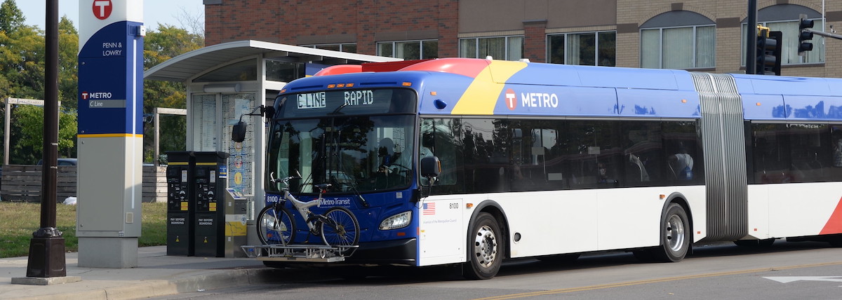
How bus rapid transit differs from local bus service
-
Service is up to 25% faster than local buses, thanks to signal priority, wider stop spacing, off-board fare payments, all-door boarding, and bus lanes in some locations
-
All stations have light, on-demand heat, emergency telephones, NexTrip real-time signs, and security cameras
How the region benefits from a growing BRT network
METRO bus rapid transit (BRT) ridership stayed strong during the pandemic and is recovering faster than other service types, reflecting a rising demand for all-day, all-purpose service.
- BRT ridership increased 115% (7.2 million rides) from 2022 to 2024
- BRT ridership accounts for about 16% of regional rides
- Rides on the D Line went up more than 97% from December 2022 to December 2023
- Orange Line weekday ridership averages 1,550+
By 2030, a planned 165-mile bus rapid transit network of 12 lines will offer fast, frequent, all-day service to many communities in the Twin Cities region. By 2030, BRT will:
- Serve 580,000 people and 600,000 jobs with all-day, all-purpose trips
- Advance transportation equity and reduce racial disparities:
- 44% of people served by this network identify as Black, Indigenous, or People of Color (BIPOC)
- 13% of households to be served by BRT don’t currently have access to a vehicle
- Help households reduce their environmental footprint:
- Typical households near BRT emit less greenhouse gas than the rest of the region and are well below the national average, according to EcoDataLab data
- Benefit from and contribute to transit oriented development (TOD), which is being concentrated in the 3% of land along high-frequency transit, including BRT corridors. That comes from the Metro Transit TOD Office’s annual Development Trends Along Transit report which found:
- In 2021, $1.6 billion or 36% of regional development was permitted near high-frequency transit.
- From 2009-2021, $13.7 billion in development was permitted near high frequency transit. This includes 41% (45,000 units) of the region’s multifamily development by permit value.
- Another $9.7 billion in development is planned along high frequency transit, which is 67% of planned future development. This will add another 35,700 multifamily units, nearly doubling the number of homes built since 2009 with immediate access to high frequency transit.
Bus rapid transit lines in development
|
Line
|
Corridor
|
Status
|
|
F Line
|
Central and University avenues, now served by Route 10
Major destinations: Downtown Minneapolis, Central Avenue business, cultural, and arts districts in northeast Minneapolis, Columbia Heights, and Hilltop; Mercy Hospital, Northtown Mall
|
Advancing through project engineering
|
|
G Line
|
Rice and Robert streets, now served by Route 62 and Route 68
Major destinations: Little Canada,Minnesota State Capitol, downtown St. Paul, West St. Paul, Dakota County Northern Service Center
|
Advancing through project planning
|
|
H Line
|
Como and Maryland avenues, now served by Route 3
Major destinations: Downtown Minneapolis, University of Minnesota, Como Regional Park, Sun Ray Transit Center
|
Advancing through project planning
|
|
Bronze Line
|
Originally envisioned to connect St. Paul, Maplewood, Vadnais Heights, Gem Lake, White Bear Township, and White Bear Lake
Major destinations: Regions and Gillette Children’s Specialty Healthcare hospitals, M Health Fairview St. John’s Hospital, and Maplewood Mall. Other destinations include Lowertown, the St. Paul central business district, Payne-Phalen, Hmong Village, and Phalen Regional Park.
|
Design advancement, route modification study Phase I and Phase II. White Bear and Maryland avenues being evaluated as a potential route in Maplewood to compare it in 2024 to the Maplewood portion of the Bruce Vento Regional Trail
|
BRT lines in service
|
Line
|
Corridor
|
|
A Line
|
Snelling Avenue, Ford Parkway (2016)
|
|
B Line
|
Lake Street, Marshall, and Selby avenues between Minneapolis and downtown St. Paul (2025)
|
|
C Line
|
Mainly along Penn Avenue, between downtown Minneapolis, Brooklyn Center (2019)
|
|
D Line
|
Emerson, Fremont, and Chicago avenues between Brooklyn Center and Bloomington (2022)
|
|
E Line
|
University Avenue/4th Street, Hennnepin Avenue, and France Avenue between University of Minnesota and Edina (2025)
|
|
Gold Line
|
Mainly on a bus-only roadway near I-94 between downtown St. Paul and Woodbury (2025)
|
|
Orange Line
|
I-35W between downtown Minneapolis, Burnsville (2021)
|
|
Red Line
|
Cedar Avenue between Apple Valley and Mall of America (2013)
|