Arterial BRT planning process
Bus rapid transit (BRT) provides an improved customer experience with frequent service and faster trips in our region’s busiest bus corridors. Learn more about Metro Transit BRT.
In 2020-2021, we used a four-step process and engaged the public to help us identify our region’s next BRT priorities. Each step was based on four principles that guided the planning process for BRT, rooted in public engagement, Metropolitan Council transit policy, and the performance of the bus network:
- Advance equity and reduce regional racial disparities
- Build on success to grow ridership
- Design a network that supports a transit-oriented lifestyle
- Ensure the long-term sustainable growth of the bus network
Step 1: Identify (Spring 2020)
Metro Transit identified 19 potential corridors to be considered for BRT. Learn more about how candidate corridors were identified (PDF).
Step 2: Screen (Summer 2020)
We conducted a screening process to narrow the 19 candidates down to a set of 11 corridors to advance for more analysis. Learn more about the screening process (PDF) and see a summary report of engagement (PDF) around this step in the process.
Step 3: Evaluate (Fall 2020)
For 10 of the corridors advanced in Step 2, we developed corridor concept plans to estimate costs, ridership, and other benefits. We evaluated the lines in more detail using evaluation criteria based on public feedback and the BRT principles, and sorted them into three tiers for near-term, mid-term, and longer term implementation. Explore the evaluation results (PDF).
Step 4: Prioritize (Winter 2020/21)
The top-performing potential BRT lines were prioritized for near-term implementation as the F, G, and H lines based on the evaluation results in Step 3, public and stakeholder engagement, and other key criteria, including cost and ridership. See a summary of engagement results (PDF) and read the final technical report (PDF).
Adopted plan outcomes
Near-term implementation: METRO F, G, and H lines
In March 2021, following months of analysis and community engagement, the Metropolitan Council adopted recommendations for the next expansions in the BRT network:
-
The METRO F Line will serve the Central Avenue corridor, largely replacing Route 10 from downtown Minneapolis to Northtown Mall via Central and University avenues.
-
The METRO G Line will serve the Rice/Robert corridor, traveling between West St. Paul and Little Canada via Robert and Rice streets and replacing portions of routes 62 and 68.
-
The METRO H Line will serve the Como/Maryland corridor from downtown Minneapolis to Sun Ray Transit Center in St. Paul via Como Avenue and Maryland Avenue, replacing and extending Route 3.
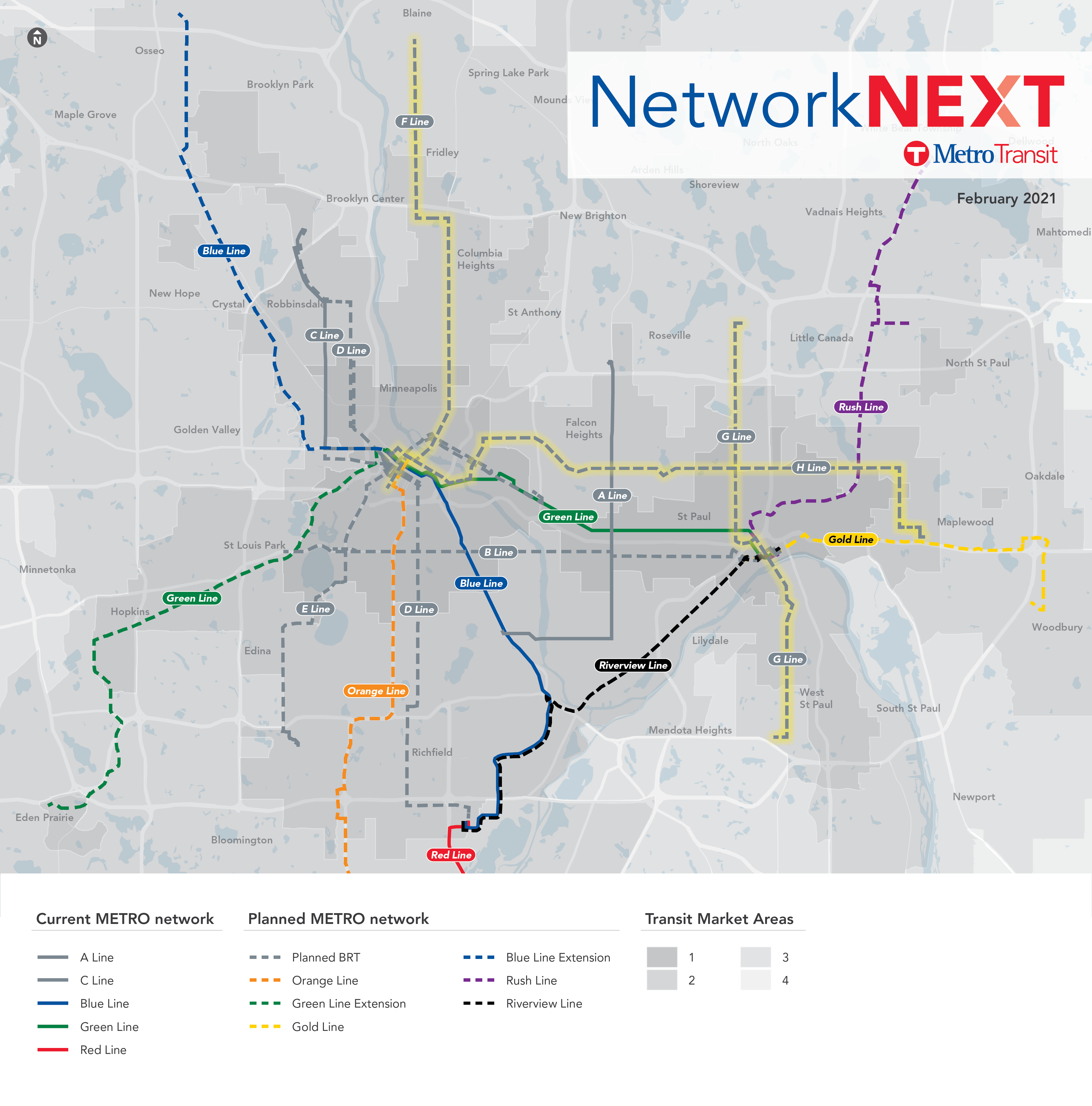
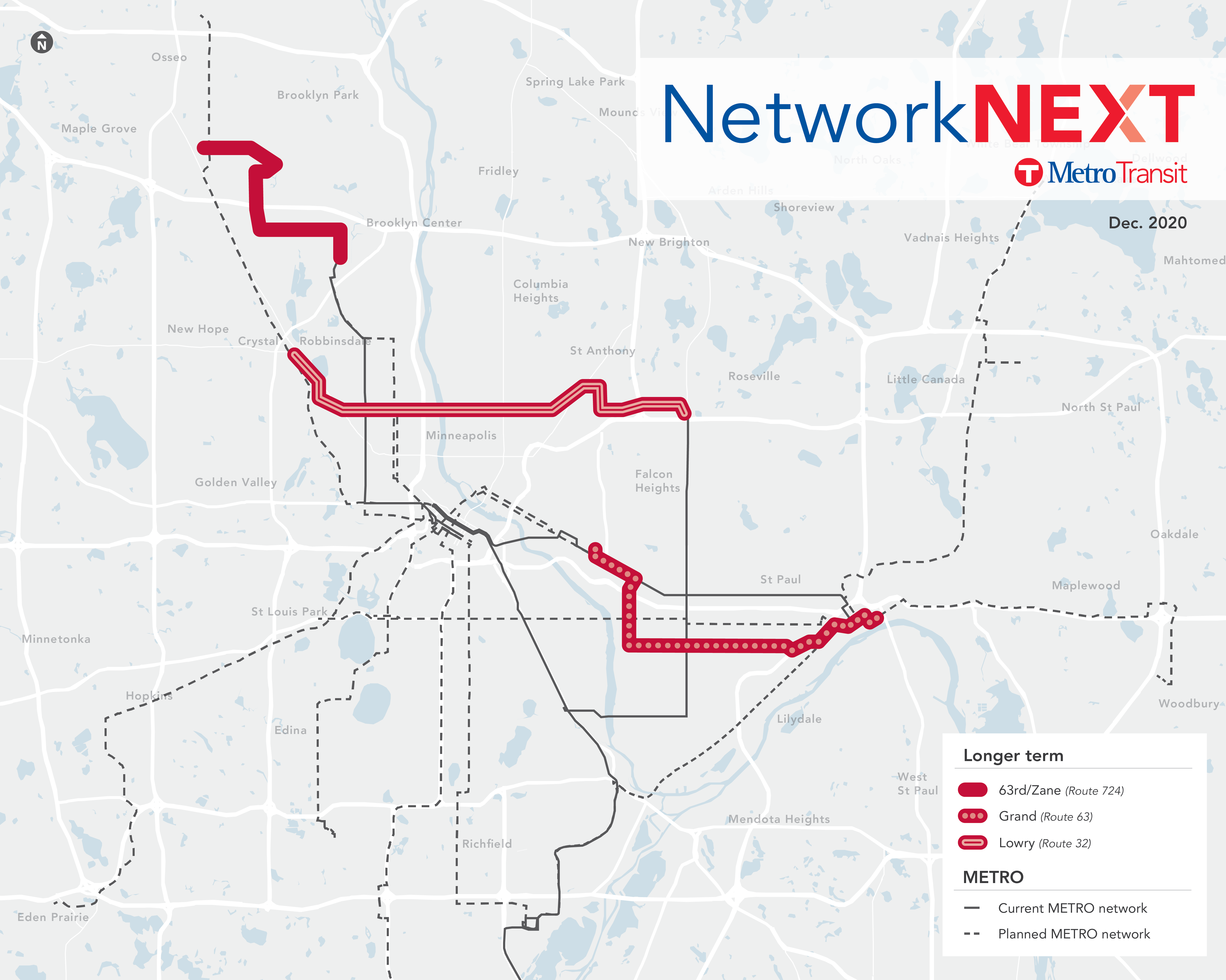
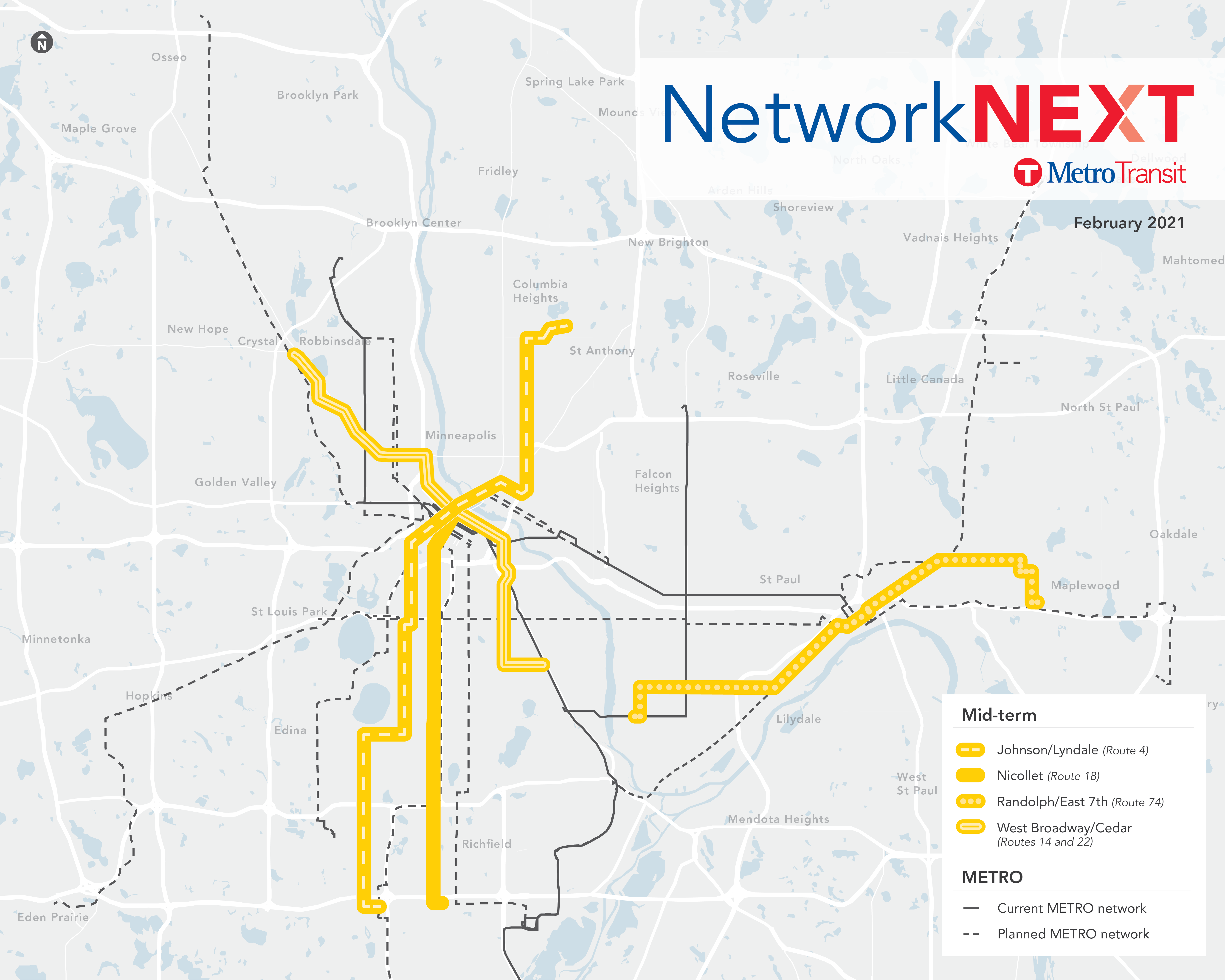
Map date February 2021
In October 2021, the Metropolitan Council adopted seven additional corridors as candidates for BRT between 2030 and 2040.
Mid-term implementation (2030-2035, pending full funding)
-
Johnson/Lyndale (Route 4) running from Bloomington to Columbia Heights via Lyndale Avenue and Johnson Street
-
Nicollet (Route 18) running from Bloomington to downtown Minneapolis via Nicollet Avenue
-
Randolph/East 7th (Route 74) running between western St. Paul and Maplewood via Randolph Avenue and East 7th Street
-
West Broadway/Cedar (Routes 14 and 22) running from south Minneapolis to Robbinsdale via Cedar Avenue and West Broadway
Longer term implementation (2035-2040, pending full funding)
-
63rd/Zane (Route 724) running from Brooklyn Center Transit Center to central Brooklyn Park via 63rd and Zane avenues
-
Grand (Route 63) running from downtown St. Paul to Westgate via Grand Avenue
-
Lowry (Route 32) running from Roseville to Robbinsdale via Lowry Avenue