Frequently asked questions
What is the METRO F Line?
The METRO F Line is a planned bus rapid transit line, like the A Line, C Line, and D Line that will provide faster and more reliable transit service in the Route 10 corridor, primarily along Central Avenue and University Avenue.
Why was the Route 10 corridor selected for bus rapid transit service?
The Route 10 corridor was prioritized for bus rapid transit through Metro Transit’s Network Next planning efforts in 2019-2021. Through Network Next, Metro Transit evaluated 19 corridors across multiple factors including equity, ridership, and costs, and engaged the public to help prioritize our region’s next METRO lines. The Metropolitan Council acted in March 2021 to name the Central Avenue corridor as the METRO F Line.
Route 10 is the fifth highest-ridership bus route in the region, both before the pandemic and today. Before the pandemic, customers took about 6,500 rides on Route 10 each weekday. In addition to providing access to places and job opportunities, Route 10 service is a critical means of moving people in the corridor and an important piece of the broader transportation network.
Central Avenue is also one of the slowest transit corridors in the region. During rush hours, buses regularly slow to average speeds of 10 miles per hour or less. Frequent stops, lines of customers waiting to board, traffic congestion, and red lights mean that buses are moving less than half the time. Reducing the time it takes for customers to get on and off the bus and the time spent stuck in traffic will significantly improve travel speeds and reliability.
How much faster will F Line service be compared to Route 10?
The goal of the F Line is to make service faster and more reliable by stopping less often, allowing customers to board faster, and stopping at fewer red lights. Similar travel time improvements have been achieved on the A, C, and D lines.
How will future bus service levels compare with today’s Route 10?
Based on preliminary recommendations, F Line service will operate as frequently as every 10 minutes, seven days a week, during the day and most of the evening.
Local service from a modified Route 10 could operate every 30-60 minutes on the portion of Central Avenue north of Columbia Heights Transit Center and connect to F Line at Northtown Transit Center. This is similar to the current Route 10N, except its southern end would be at Columbia Heights Transit Center, rather than continue into downtown. To get downtown, customers using the modified Route 10 would be able to transfer to the F Line at Central & 41st Avenue Station adjacent to the Columbia Heights Transit Center.
What will be the frequency and hours of service?
The F Line will provide frequent service all day on weekdays, Saturdays, and Sundays. Exact schedules and service plans will be formed in the months leading up to the start of F Line service.
What will F Line buses look like?
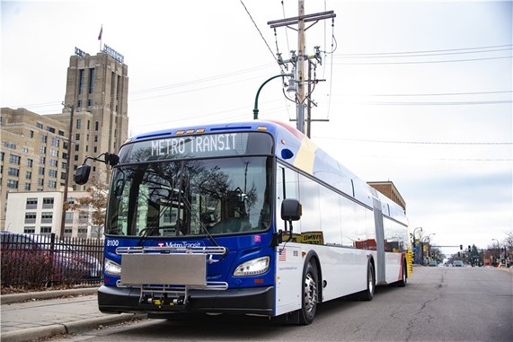
The F Line will use recognizable 60-foot “articulated” buses with wider aisles, more seating capacity, and additional doors so more people can get on and off easily. F Line customers should feel less crowded and more comfortable as they travel.
How will fares be collected on the F Line?
F Line customers will pay before boarding for faster stops using ticket machines and card readers at the station or the Metro Transit’s app on their smartphone. Customers enter the bus through any door, speeding up the boarding process. Metro Transit officers will check fare payment.
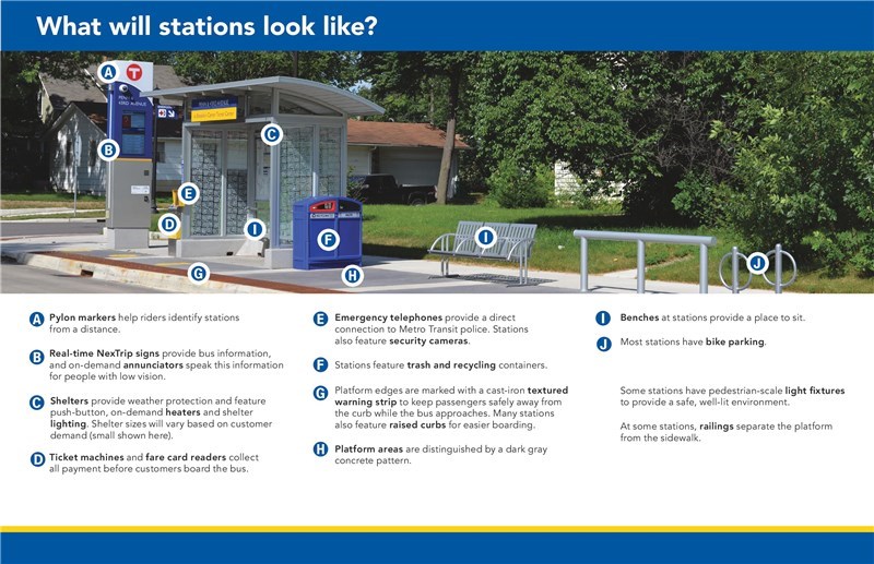
What features will F Line stations include?
F Line station features include:
- Real-time NexTrip signs with on-demand audible announcements
- Shelter lighting
- Push-button heating
- Containers for garbage and recycling
- Security cameras
- Emergency telephones
- Benches
- Bike parking
What are MnDOT's plans for Central Avenue and University Avenue?
MnDOT has identified major roadway improvements for Highways 47 and 65 in a recent transportation planning study. These improvements are part of a broader plan to enhance the transportation infrastructure along these corridors.
Is Metro Transit collaborating with MnDOT on this project?
Metro Transit is collaborating with MnDOT to ensure that future transit and roadway investments along the F Line corridors are compatible. This partnership will allow both agencies to coordinate efforts and provide a safer and more accessible corridor for all users, including people walking, rolling, biking, and riding transit along Central Avenue.
When will construction of the F Line begin?
Construction of the F Line on Central Avenue (Highway 65) is now expected to begin in 2028, instead of the initially planned 2025. This adjustment was made to align with MnDOT's schedule for roadway improvements in the corridor.