B Line routing and stations, bus service, and bus priority treatments
Where will stations be located?
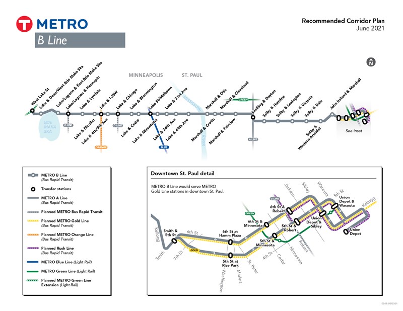
The B Line will travel approximately 12.6 miles between Minneapolis and downtown St. Paul along Lake Street, Marshall Avenue, and Selby Avenue, stopping at 33 locations along the corridor with an average of 2-3 stops per mile.
Stop locations have been refined based on initial recommendations for station areas shared in fall 2019. 83% of current Route 21 customers board the bus at or within one block of these planned stop locations.
The comment period for the Recommended Corridor Plan is now open until August 13.
View plans for individual stations.
How will future bus service levels compare with today’s Route 21?
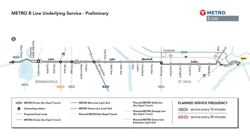
B Line service would operate every 10 minutes, seven days a week during the day and most of the evening. In addition to B Line service:
- A revised Route 21 will run every 30 minutes between Hennepin Avenue and Minnehaha Avenue in Minneapolis. Route 21 will serve all local stops and B Line stops. Individual route letters for Route 21 will be eliminated.
- Service between Selby Avenue and the Midway area will be replaced by a new local bus, Route 60, which will provide local service with buses running every 30 minutes.
- Route 53 service will be evaluated as the B Line approaches implementation.
Final service plans, including frequency and termini for local bus service along the B Line corridor, will be developed later in project development as the B Line nears implementation and as recovery from the COVID-19 pandemic continues. Key considerations will include public feedback, operating budget/staffing constraints, Route 21 ridership patterns, redevelopment/land use patterns, and anticipated transit travel times based on bus priority treatments. Additionally, Metro Transit will continue to explore potential changes to other routes in the project area and/or opportunities for shared mobility and microtransit to complement planned fixed route transit service.
How can the B Line move people faster?
A key B Line project goal is to improve travel times by approximately 20% compared to the existing Route 21. Standard BRT improvements will combine to reduce various sources of delay. These include:
· Increased stop spacing
· Efficient stop placement
· Off-board fare payment
· All-door boarding
However, preliminary analysis indicates that further improvements through bus priority treatments will be necessary to reach the project’s goals for speed and reliability.
Bus priority treatments can be implemented in different ways at different locations. Learn more about specific types of bus priority treatments being considered for the B Line (PDF).
To better understand how different packages of bus priority treatments could be implemented across the entire B Line corridor, Metro Transit developed two initial bus priority concepts: a Limited Bus Priority concept and an Extensive Bus Priority concept. Working closely with Hennepin County and the City of Minneapolis, Metro Transit developed a third scenario that would include bus priority treatments along with coordinated roadway changes to address other agency goals for the corridor, including measures to improve traffic safety and bicycle connections along portions of the Lake Street corridor while attaining acceptable traffic operations. This scenario, called the Balanced Bus Priority concept, is also described below.
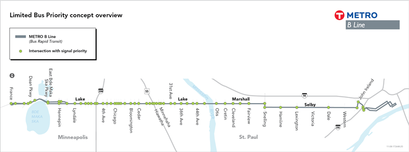
Limited Bus Priority concept
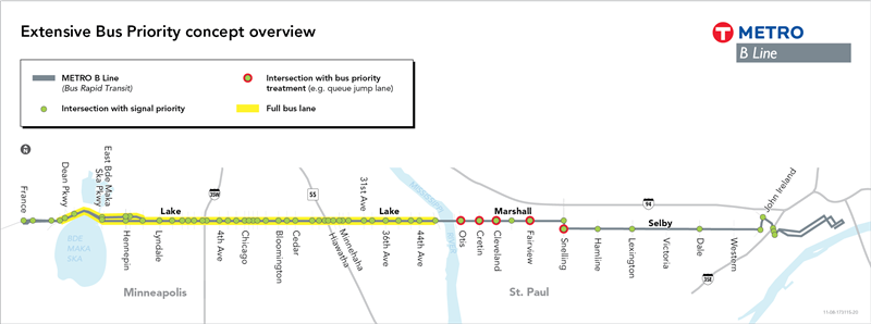
Extensive Bus Priority concept
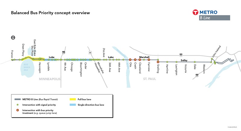
Balanced Bus Priority
The Limited Bus Priority concept is focused on modifying traffic signals to provide more “green” time to buses passing through intersections.
The Extensive Bus Priority concept retains traffic signal modifications but adds roadway changes in a number of locations across the corridor.
The Balanced Bus Priority concept combines measures to improve transit speed and reliability for the B Line with roadway changes intended to address broader City and County goals for the corridor, including traffic safety and bicycle connections.
Recommendations for B Line bus priority treatments will continue to be refined and finalized as the project moves through planning and engineering. Because Metro Transit does not own or operate streets, any changes would need to be made in partnership with the corridor cities and counties.
B Line Corridor Plan