Frequently Asked Questions
What is the METRO B Line?
The METRO B Line is a planned bus rapid transit line, like the A, C, and D lines, that will provide faster and more reliable transit service in the Route 21 corridor along Lake Street, Marshall Avenue, and Selby Avenue.
Why was the Route 21 corridor selected for bus rapid transit service?
Before the pandemic, customers took more than 10,000 daily rides on Route 21, making it Metro Transit’s second busiest bus route. Buses carry approximately 20% of people traveling on Lake Street but make up less than 2% of vehicle traffic. Lake Street is also one of the slowest transit corridors in the region. During rush hours, buses move at an average speed of 8 miles per hour. Frequent stops, lines of customers waiting to board, and red lights mean that buses are moving less than half the time.
Previous studies in 2012 and 2014 found that enhanced bus service in the Lake Street corridor would perform well in the corridor. In 2016, this corridor was identified as the B Line project and slated to become the region's fourth arterial bus rapid transit line.
How much faster will B Line service be compared to Route 21?
The goal of the B Line is to make service approximately 20% faster than current travel time by stopping less often, allowing customers to board faster, and stopping at fewer red lights. Similar travel time improvements have been achieved on the A Line, C Line, and D Line.
How will future bus service levels compare with today's Route 21?
The B Line will provide frequent service all day on weekdays, Saturdays, and Sundays.
Currently, local bus service on Lake Street is planned to operate every 30 minutes on the portion between Hennepin Avenue and Minnehaha Avenue. Initial plans also call for a new local bus, Route 60, that would run every 30 minutes along Selby Avenue and connect to the Midway area of St. Paul.
Service plans will be refined before service launches in June 2025. Metro Transit plans to begin planning and engagement around detailed service plans later in 2024.
What will B Line buses look like?
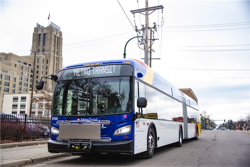
The B Line will use recognizable 60-foot “articulated” buses with wider aisles, more seating capacity, and additional doors so more people can get on and off easily. B Line customers should feel less crowded and more comfortable as they travel.
How will fares be collected on the B Line?
B Line customers will pay before boarding for faster stops using ticket machines and card readers at the station or the Metro Transit’s app on their smartphone. Customers enter the bus through any door, speeding up the boarding process.
What features will B Line stations include?
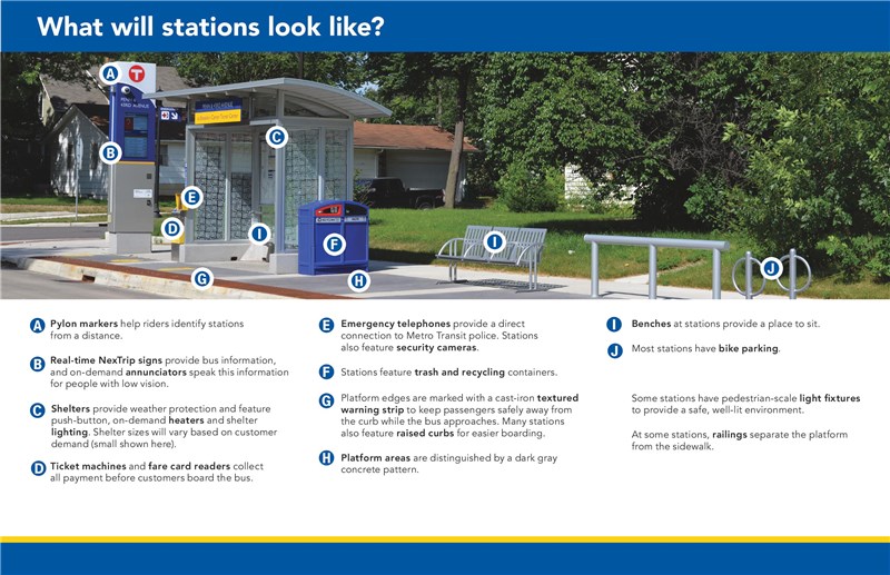
B Line station features include:
• Real-time NexTrip signs with on-demand audible announcements
• Shelter lighting
• Push-button heating
• Containers for garbage and recycling
• Security cameras
• Emergency telephones
• Benches
• Bike parking
What other improvements to Lake Street are being made with the B Line project?
Construction of the METRO B Line project provided an opportunity to rethink and improve how Lake Street is used by all who walk, bike, roll, drive, and use transit.
Today, Lake Street is the highest crash corridor in Minneapolis, and one of the highest in all of Hennepin County. Past studies have found that left turns being made from the shared through-lane have led to many crashes along Lake Street. The changes to Lake Street are expected to reduce crashes and enhance safety for all users.
Aside from the bus rapid transit stations that will serve the METRO B Line, the changes you are seeing on the street are designed by Hennepin County in collaboration with the City of Minneapolis and Metro Transit. These changes are designed to enhance safety for people walking and rolling, improve transit times and reliability, reduce crashes, and enhance the overall user experience for everyone along the corridor.
The Lake Street improvements include:
-
A four-to-three lane conversion with new left-turn lanes to reduce severe crashes and make it easier for people walking and rolling to cross Lake Street.
-
Red bus-only lanes in one or both directions to improve transit speed and reliability for one of the busiest transit routes in the region.
-
Transit signal priority to keep buses moving through intersections.
-
Accessible pedestrian ramp improvements at dozens of intersections
-
Minimal changes to on-street parking, with many areas keeping all on-street parking spaces.
Read more about the history of the corridor and the coming changes in the Transforming Lake Street report.
View the interactive map to see what will be constructed with the B Line project and Lake Street improvements.
When will the bus-only lane on East Lake Street be completed?
The new westbound bus-only lane on East Lake Street between 27th Avenue and the Mississippi River opened in November 2023, helping Route 21 buses stay on schedule. An early cold snap curtailed efforts to paint the full bus lane red in 2023. Red paint will be added from 44th Avenue to 27th Avenue in spring 2024.
How is the project funded?
The B Line is fully funded through a mix of federal, state, and Metropolitan Council funds. The estimated cost of the project is $65 million.
Lake Street improvements are funded through a mix of funding from Hennepin County, the City of Minneapolis, and the federal government, including a $12 million RAISE grant.